Project Background
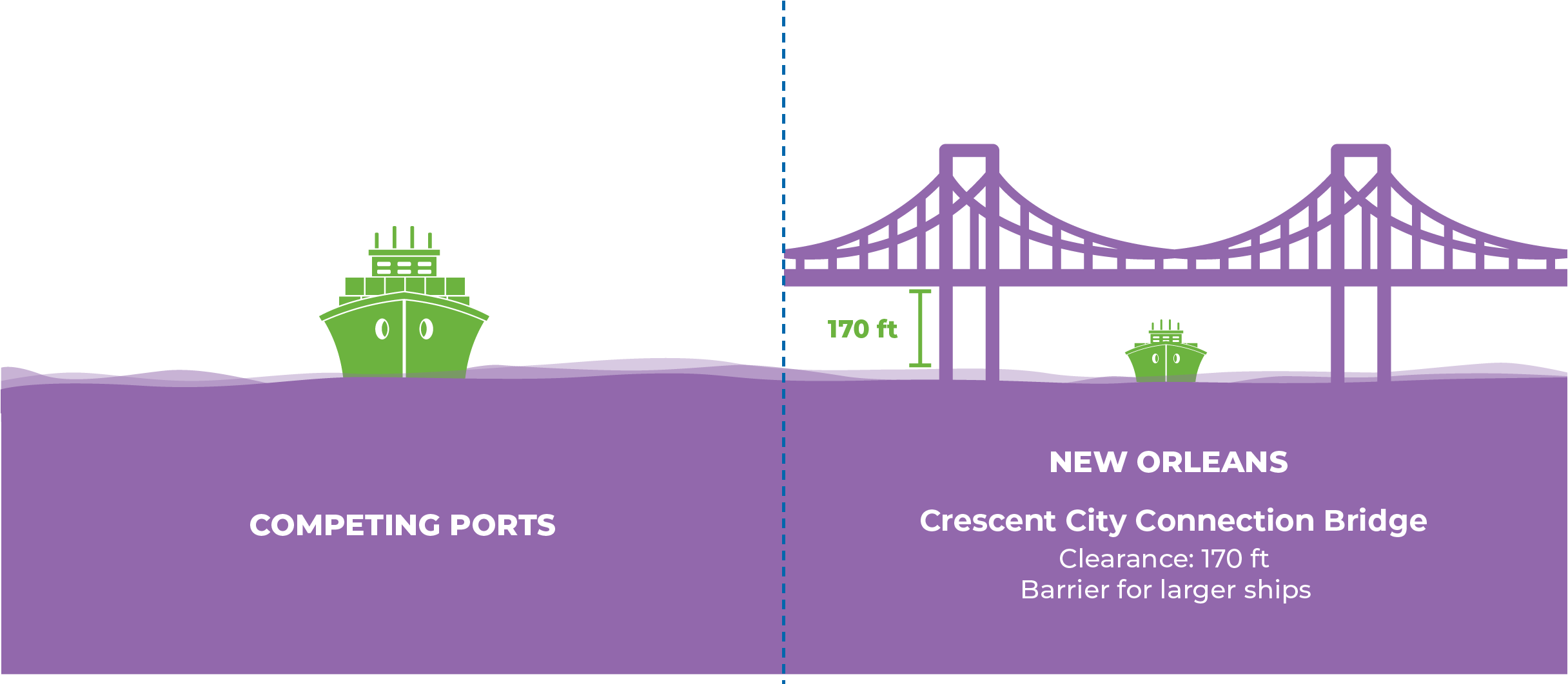
The proposed Louisiana International Terminal will be our state’s gateway to modern global markets. Located in Violet, the terminal will avoid the height limit set for ships by the Crescent City Connection bridge in New Orleans.
By serving vessels of all sizes, the Louisiana International Terminal will:
- Strengthen the St. Bernard Parish economy.
- Attract distribution centers, logistics companies, and value-added services to the region.
- Expand and protect Louisiana’s ability to import and export goods.
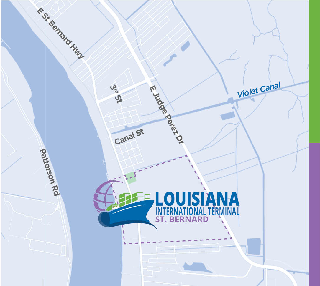
Click image to open Google maps.
Timeline
This project is currently in the design phase and proceeding through the U.S. Army Corps of Engineers’ environmental permitting and review process. Construction cannot begin without the applicable permits.

Click to enlarge.
Why Build a Terminal?
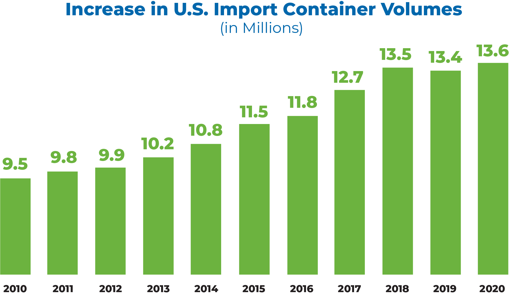
Container shipping is how many Louisiana products get to market and how we import the goods that stock our store shelves and arrive at our doorsteps.
The number of containers moving in and out of the U.S. has climbed for over 10 years. As more containers move around the globe, the ships that carry them are also getting bigger.
Click to enlarge.
Click to enlarge.
Louisiana is at a critical juncture. Without a container terminal that can welcome larger vessels, shipping companies will start to skip Louisiana, taking their business to competing states instead.
Project Benefits
Port NOLA is in a position to build a new international container terminal to boost the economy and future trade opportunities. With a new terminal our state will experience substantial benefits, including:
- Over 18,500 new jobs
- Over $1 billion in new state tax revenue
- $97.3 billion gained in industry sales
If No Action is Taken
Louisiana will lose existing jobs and tax revenue as well as logistics and business opportunities. Over the next 10 years, Louisiana could lose:
- 9,552 existing jobs lost
- $205 million in state taxes
- $10.3 billion in industry sales
Economic impact estimates prepared by Dr. Dek Terrell with Lewis Terrell and Associates.
Our Economic Future
The Louisiana International Terminal will be a major economic driver in St. Bernard Parish as well as the region and state.
New Jobs
The Louisiana International Terminal and related businesses will bring new, family-supporting jobs to St. Bernard Parish. As business at the terminal grows over time, more family-supporting jobs will be created.
To help locals apply for these jobs, the Port is working on concepts for workforce development and job training with partners like:
- The International Longshoremen’s Association (ILA)
- Nunez Community College
- Urban League
- Louisiana Economic Development (LED) Fast Start
- Regional and local economic development organizations
- And more
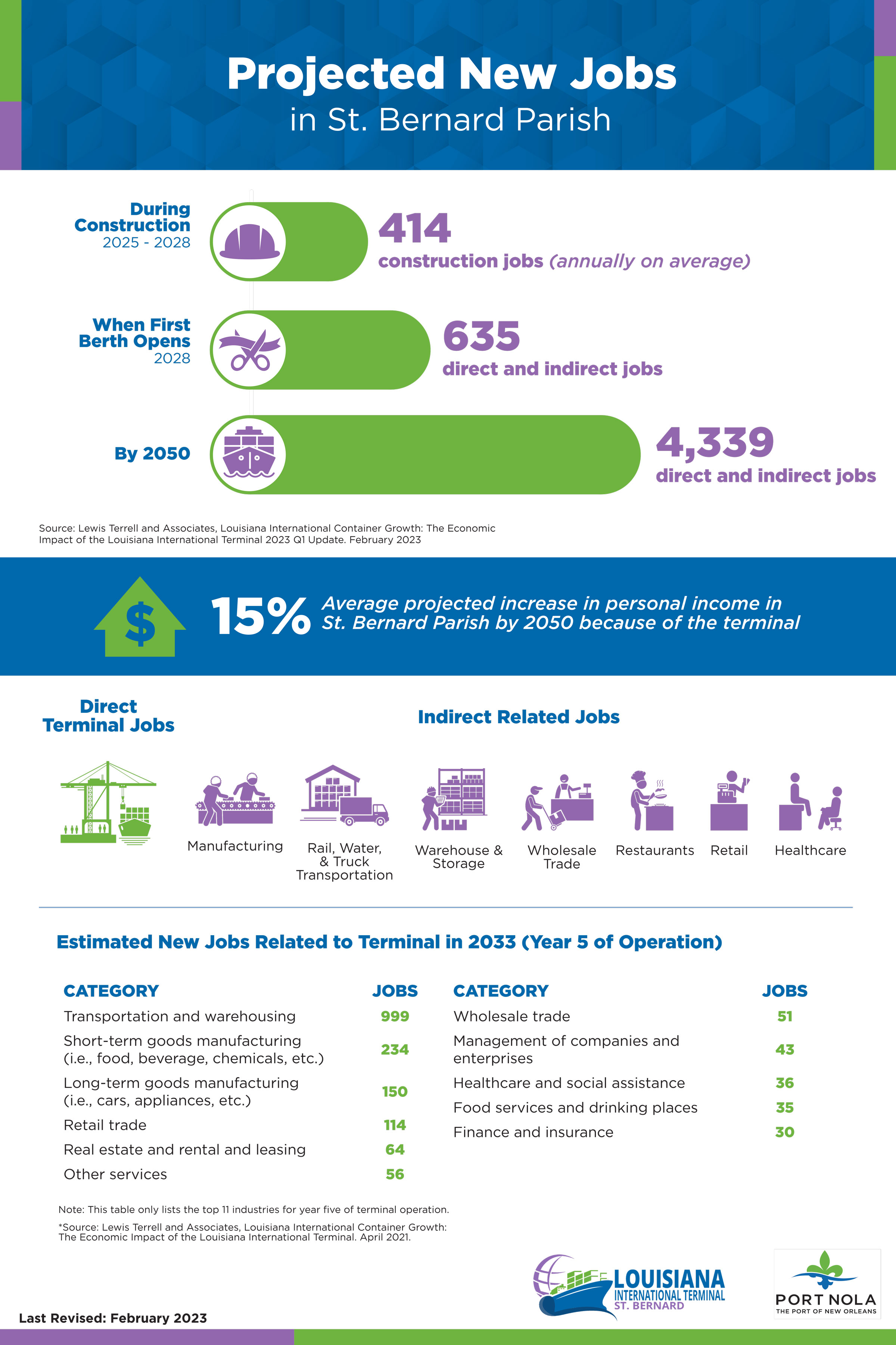
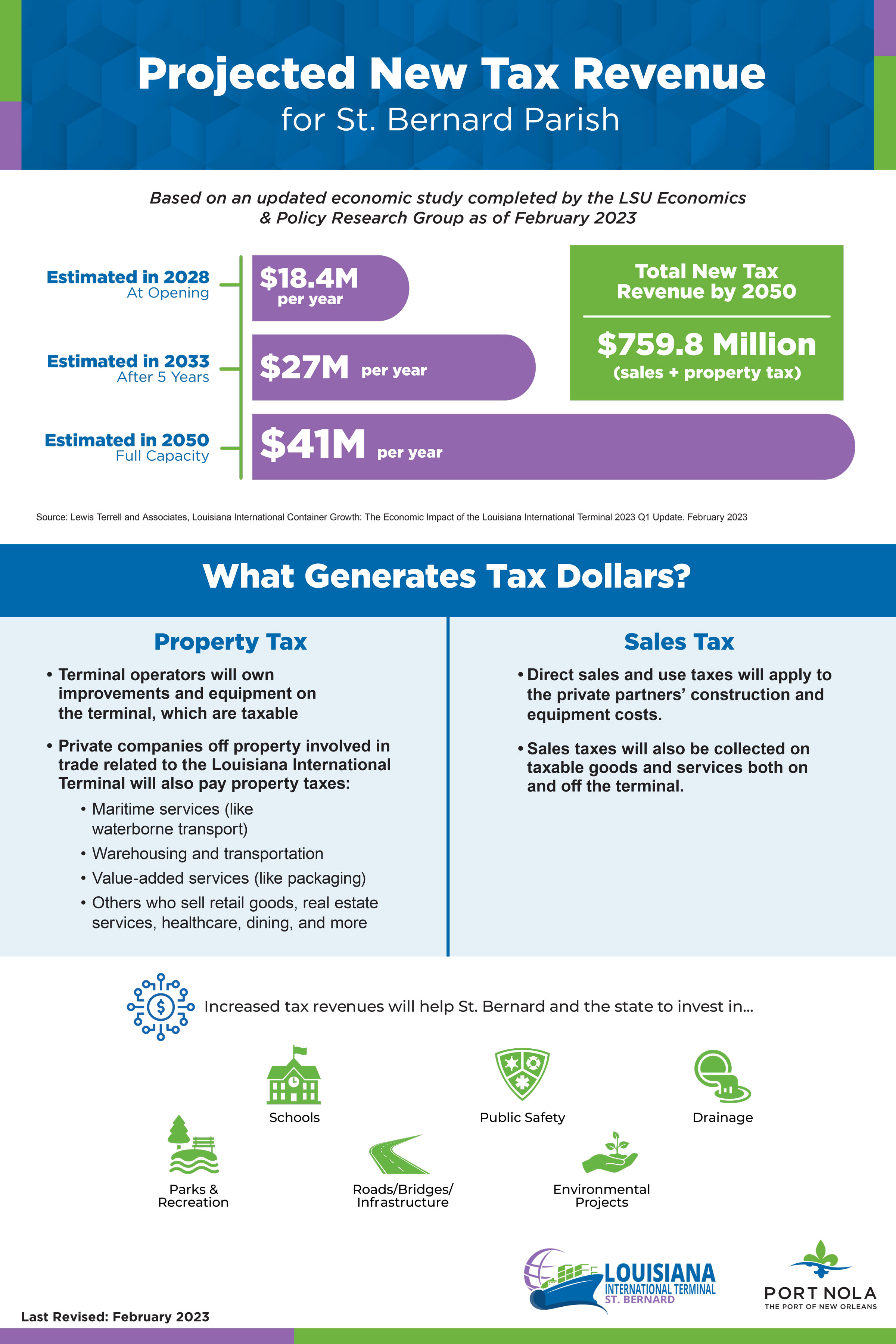
New Tax Revenue
Tax revenue from the terminal and related activity will grow over time as cargo volumes increase. This will give St. Bernard Parish funds to invest in resources and services for community members. For more information view this handout on the project's projected economic impact.
If you’re interested in doing business with the Port of New Orleans and the Louisiana International Terminal, register as a vendor at portnola.com/business/procurement.
St. Bernard Transportation Corridor
Traffic flow is key to the success of the Louisiana International Terminal and to the local quality of life. Port NOLA is working with regional and state agencies to deliver transportation improvements when or before they are needed.
The St. Bernard Transportation Corridor is envisioned as an elevated roadway outside the levees along the 40 Arpent Canal. This parallel project would give St. Bernard Parish another connection to the interstate system.
The New Roadway
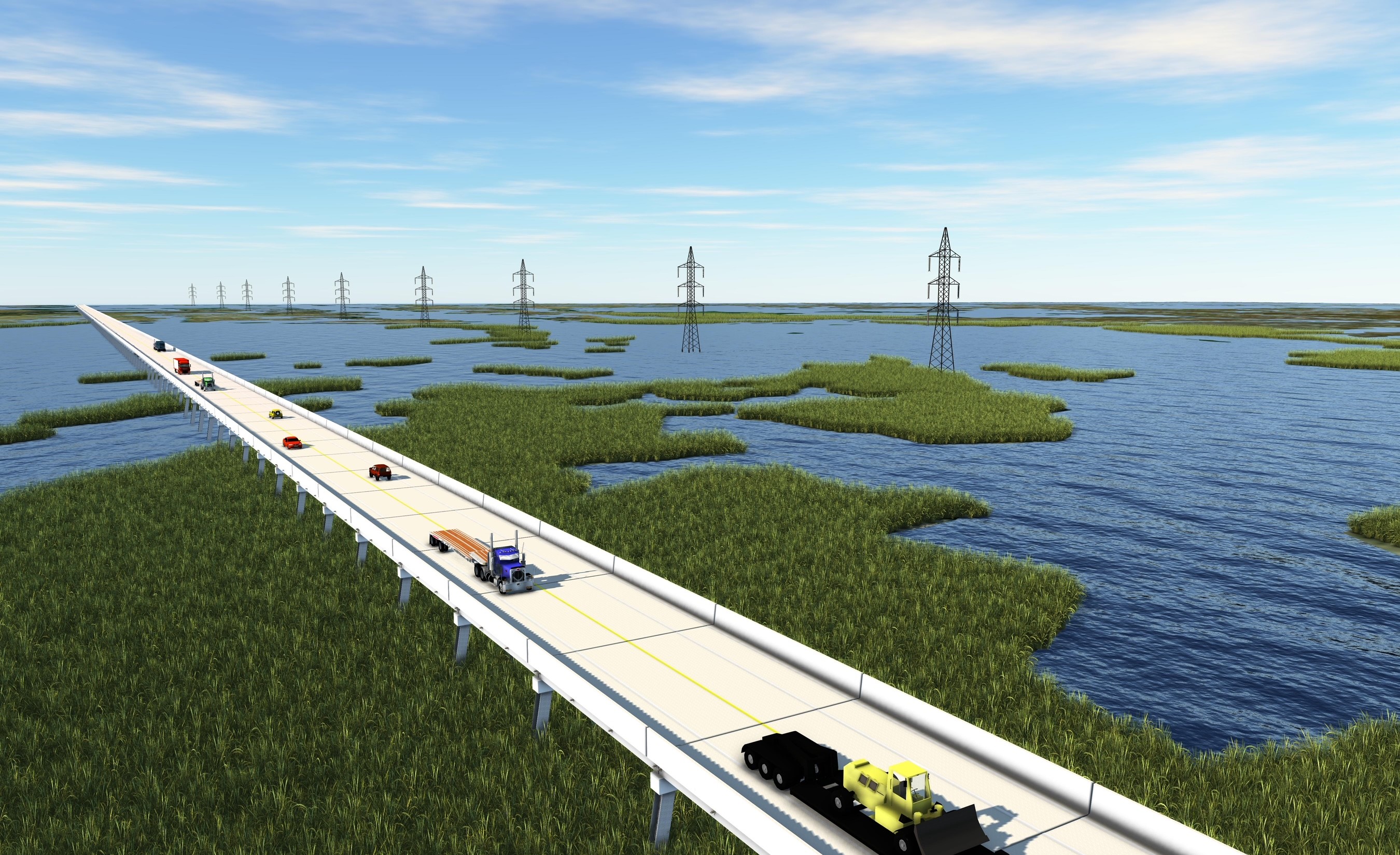
Click to enlarge.
The new elevated roadway would:
- Help relieve traffic congestion that would happen with or without the terminal
- Offer an alternative route for trucks
- Serve as another hurricane evacuation route for residents in the parish
- Attract and keep new economic investments and industries
- Reduce safety concerns on local roadways
Planning & Funding
The Regional Planning Commission and the Louisiana Department of Transportation and Development are responsible for this project and will follow their own process to develop it.
Click or tap on the icons below to learn more.

Funding
$50 million is already committed by the Louisiana Legislature for analysis, planning, and design phases. Alongside state and federal funding, we anticipate a private partner will provide the additional finances for construction. A toll on container trucks would likely be collected to repay the private partner.

Traffic Studies
- Formally document the need for a roadway
- Identify potential impacts to the human and natural environments

Planning & Environmental Studies
- Determine the roadway alignment
- Develop a budget
- Collect public input
- Identify additional projects to improve traffic flow in the parish

Design
- Finalize roadway design
- Obtain necessary permits
- Develop a traffic management plan for construction

Construction
- Build the roadway according to design
W. Smith Jr. Elementary School
W. Smith Jr. Elementary School is located within the terminal’s proposed boundaries. Port NOLA owns the property around the school but does not own the property on which the school sits.
Port NOLA is ready to fund the construction of a new elementary school now. The sooner the new school is built, the less impact terminal construction will have on students.
The School Board will use funds provided by Port NOLA for the construction of a new, modern school. We are in discussions with the School Board to agree on a path forward. Port NOLA supports a public process involving the community and honoring the history of Violet Consolidated.
We have identified two potential locations for the new school on land Port NOLA already owns.
Site A
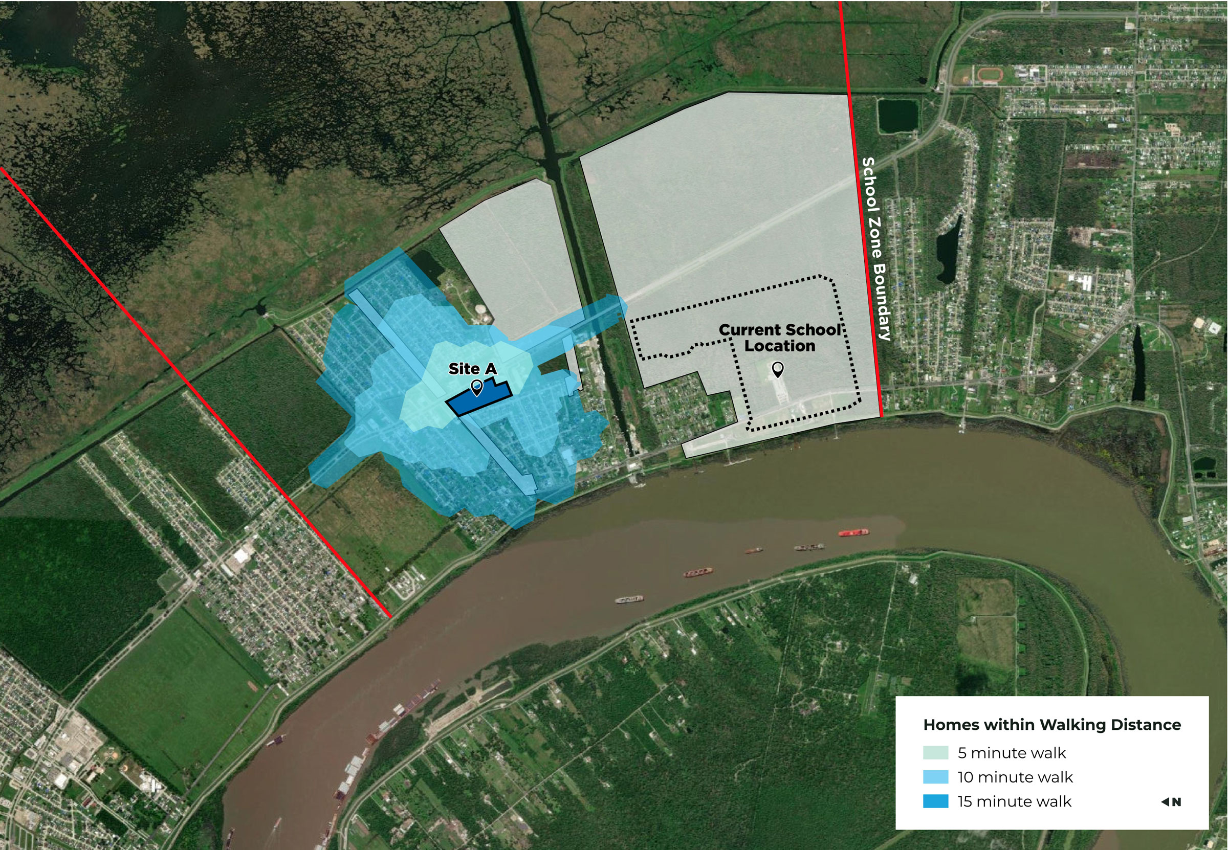
Click to enlarge.
Walkability for Site A at the Northwest corner of Judge Perez and Colonial Blvd
Site B
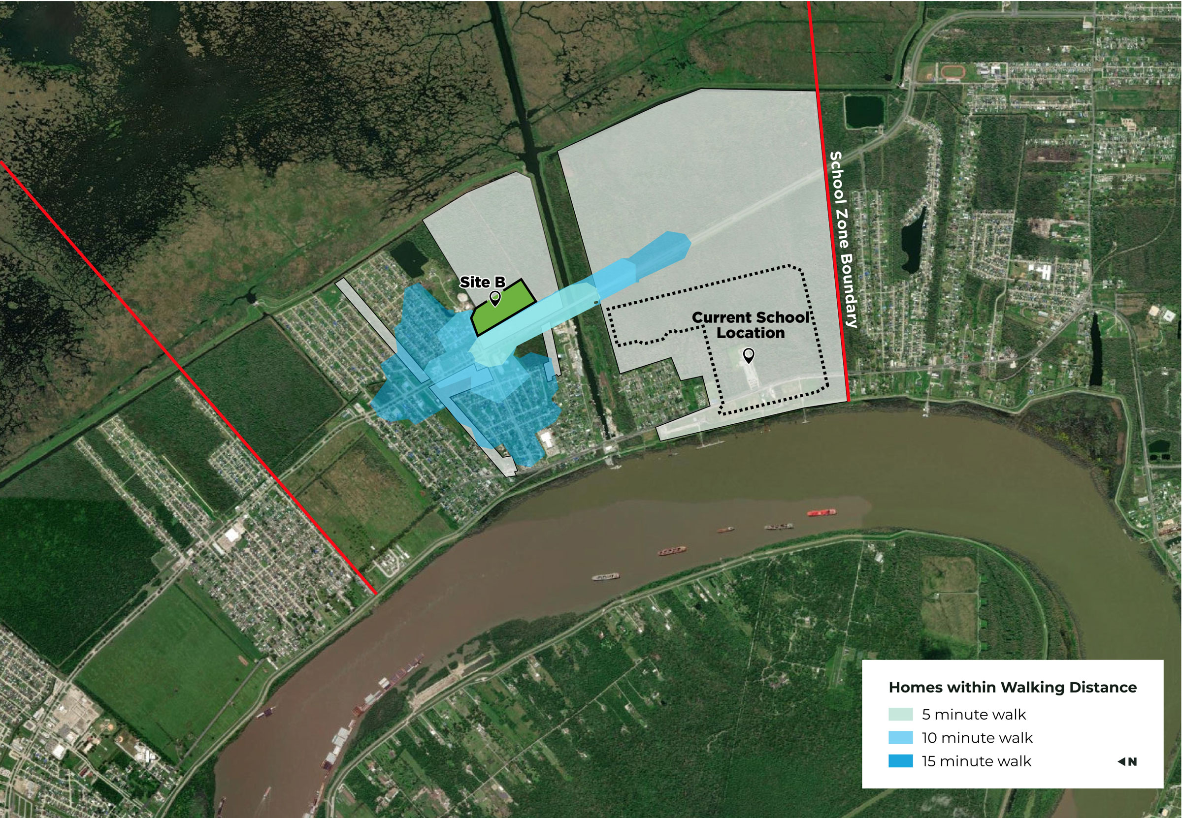
Click to enlarge.
Walkability for Site B at the Southeast corner of Judge Perez and Colonial Blvd
Violet Park & Merrick Cemetery
Violet Park
Violet Park is located in the proposed terminal boundaries. We are working with St. Bernard Parish to fund the construction of a replacement park within Violet. We will share your feedback with St. Bernard Parish's Recreation Department.
Merrick Cemetery
Port NOLA is committed to protecting the Merrick Cemetery. The terminal layout protects easy access, adds more space between the cemetery and the active areas of the terminal, and provides additional land for future expansion.
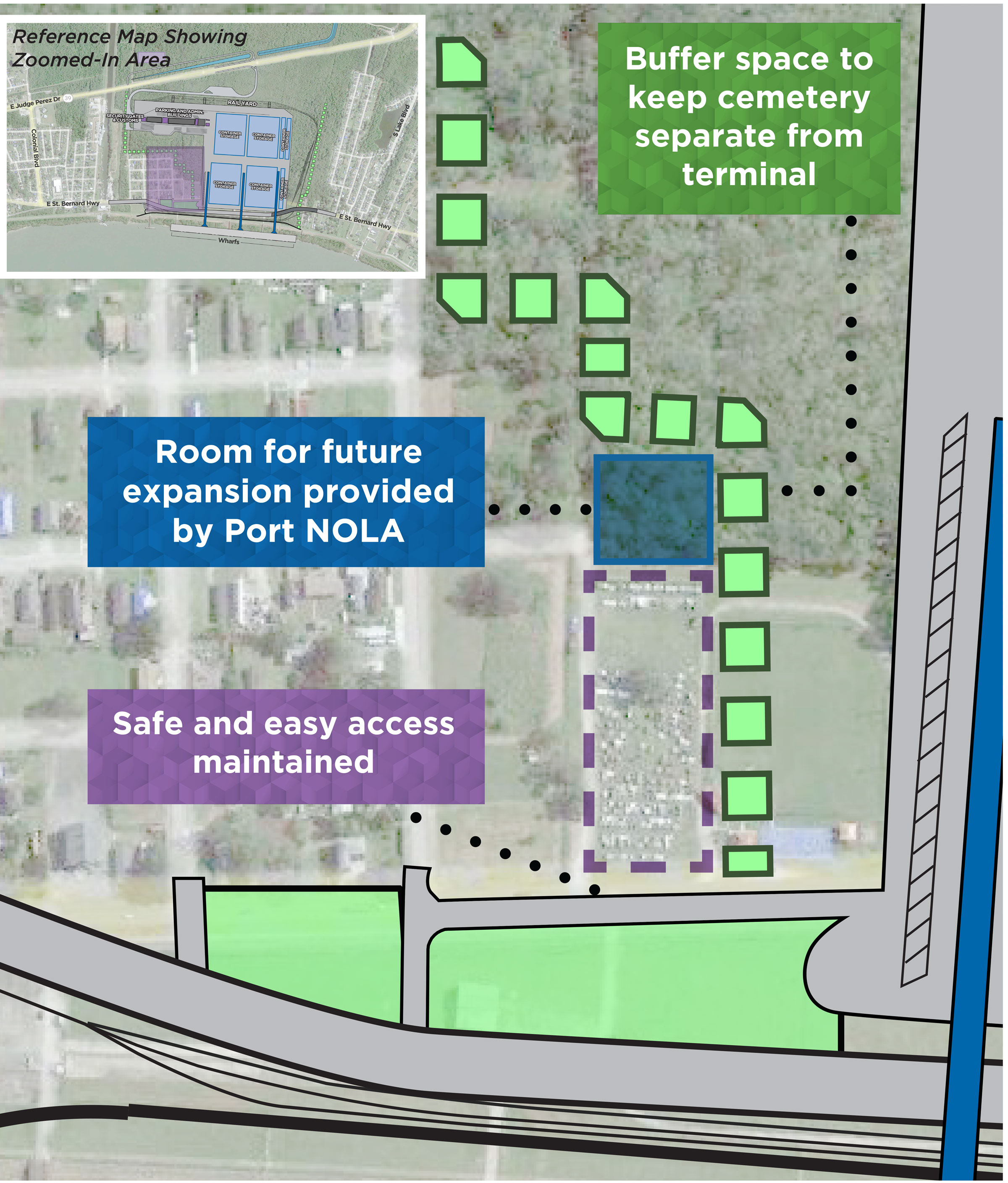
Click to enlarge.
Sustainability
Port NOLA and the terminal operators are incorporating sustainable practices into the terminal design to protect local quality of life. We participate in voluntary environmental protection programs, including Green Marine and the Clean Truck Replacement Initiative Program. For the Louisiana International Terminal, the terminal operators have also agreed to participate in Envision, another industry-leading sustainability program.
Sustainability
As we develop the Louisiana International Terminal, Port NOLA is incorporating sustainable practices to protect local quality of life.
Click or tap below to learn more.

Shore Power
- Allows cargo ships to plug into electric power while at the dock, minimizing the need to run diesel engines while at berth.
- Up to 98% potential reduction in emissions from ships at berth.

Container-on-Barge Service
- Involves transporting containers on barges (versus trucks) through inland waterways.
- In 2019* this reduced greenhouse gas emissions by 9,400 tons and decreased diesel fuel use by 800,000 gallons.
*Based on 2019 data moving about 42,000 containers on barge vs. truck between New Orleans, Baton Rouge, and Memphis.

Electric Vehicles and Equipment
- Reduces air emissions, fuel use, and equipment noise.
- We are working with terminal operators to explore options for low-emissions equipment and vehicles on the terminal.

Local Members of Green Marine
Voluntary, maritime environmental certification that measures improvements annually across categories, such as:
- Environmental Leadership
- Greenhouse Gas Emissions
- Spill Prevention & Stormwater Management
- Community Impacts

Clean Trip
- The Clean Truck Replacement Incentive Program (TRIP) is available for ST. Bernard Parish truck owners.
- It provides grants up to $35,000 to replace older vehicles.
- Over 90% reduction in small particulate matter and nitrogen oxide pollution for repaired trucks.
Envision
A voluntary sustainability program to protect local quality of life and the environment.
Click or tap the topics below to see how Envision will measure our performance.

Quality of Life
- Enhance public health and safety
- Minimize construction impacts
- Advance equity and social justice
- Preserve cultural resources
- Enhance public space and amenities

Natural World
- Manage stormwater
- Enhance surface and groundwater quality
- Enhance wetland and surface water functions
- Control invasive species
- Protect soil health

Climate & Resilience
- Reduce air pollutant emissions
- Reduce greenhouse gas emissions
- Maximize resilience

Resource Allocation
- Reduce waste
- Use renewable energy
- Reduce energy consumption
- Reduce water consumption
- Monitor water systems

Leadership
- Establish a sustainability management plan
- Develop a sustainable project for the community
- Stimulate economic development
- Help the local workforce grow and develop
The Environmental Study Process
A successful project respects the community’s needs. Port NOLA has been gathering public and stakeholder input for over a year to design a container terminal that works well for the shipping industry, neighbors, region, and state.
Through two formal public comment periods and a series of open houses in 2022, the community asked a variety of questions about the terminal and its potential impacts. Click on the topics below to find out how we plan to address the feedback. Then, let us know if we’re missing something by leaving a comment.
Click or tap below to learn more.

Impact to Neighboring Residents
The new terminal layout includes more space between neighborhoods and the terminal.
We will conduct detailed studies to understand potential impacts to noise, light, and traffic. Based on the results, we will incorporate project features to lessen impacts. This could include landscaping, sound walls, etc.

Air Quality
We are conducting detailed air quality studies to understand potential impacts. We will consider existing refineries and other potential future developments in the area to understand the collective impacts of the terminal and these other refineries and developments.
We, along with our private partners, are making major investments in green technologies to limit emissions. This includes:
- Shore power
- Low-emissions vehicles and equipment
- Container-on-barge services
- Clean TRIP engine replacement
Water Quality
We plan to study water and wastewater quality. The new terminal layout includes an on-site drainage system to collect terminal runoff. The Mississippi River is naturally deep at the proposed site, so it requires minimal construction dredging and little to no maintenance dredging.

Road and Rail Traffic
We are working with the Regional Planning Commission, the Department of Transportation and Development, and St. Bernard Parish to conduct traffic studies and assess potential traffic impacts. The new terminal layout includes:
- An overpass to avoid a rail crossing
- Support for the construction of the St. Bernard Transportation Corridor.

Cultural Resources
A Phase I cultural resource study has already been completed. No significant archaeological resources, historical, or cultural resources were found at the proposed site and no tribal objections have been submitted to the U.S. Army Corps.
We will conduct further cultural resource studies.
The new terminal layout keeps the St. Bernard Highway, which is a Scenic Highway, near its current route.

Wetlands
We will analyze the project’s impacts on wetlands and develop a mitigation plan in accordance with federal regulations.
Port NOLA will fully mitigate all impacts to wetlands within the watershed, as required by the U.S. Army Corps of Engineers in accordance with federal regulations.

Alternative Locations
We studied other potential locations, and Violet is the best fit because of:
- Naturally deep water at the dock
- Access to four interstates
- Access to six Class-I rail connections
- 100-year level hurricane protection
- Excellent waterside navigation
- No height restrictions for ships, such as bridges

Recreation, Tourism & Commercial Fishing
We will study potential impacts on recreational and tourist activities. The new terminal layout includes:
- Space for a bike and pedestrian path (if desired by the parish)
- Relocation of the Violet playground.

Local Social and Economic Impacts
We aim to positively impact Violet and the parish with job opportunities and tax revenue that can uplift the communities.
We plan to conduct environmental justice assessments in compliance with applicable guidance and regulations.
We will conduct a socioeconomic impact analysis that reviews the projects impacts on:
- Housing
- Public services
- Public safety
- Population
- Property values
- Tax revenue
- Community cohesion due to project-induced changes (i.e., traffic and land use)

Land Use
We are conducting site studies to understand:
- Underground soil conditions
- Levee and riverbank stability
- Placement of water, electric, gas, etc., utility lines
- Existing groundwater levels
- Placement of pipelines or other infrastructure in the area

Threatened & Endangered Species
We plan to complete biological assessments to understand the project’s impacts on threatened and endangered species and their habitats.

Drainage
We plan to develop a stormwater management plan and conduct drainage and flood hazard analyses. The new terminal layout includes:
- An on-site drainage management system
- A new drainage canal to the 40 Arpent Canal
- A new drainage pump station on the 40 Arpent Canal
The new drainage system will not burden the existing Violet drainage system.
Navigation
An initial navigation study has already been completed. Violet was selected for its deep water and other characteristics that make it safe for large ships to navigate.
We will further analyze the potential impacts of terminal operations on Mississippi River navigation.
Before construction can begin, Port NOLA needs the U.S. Army Corps of Engineers to issue a variety of permits. Federal law requires the Army Corps of Engineers to weigh the project’s potential impacts on the natural and human environments as part of the permitting process. At the request of the Army Corps of Engineers, Port NOLA hired an outside consultant to conduct a range of studies - these studies are described above.
Port NOLA will use the study findings to design a better terminal. The results will also be provided to the Army Corps of Engineers to review during the permitting process.


